Types of Roads

Sealed roads
The Rural City of Wangaratta manages and maintains an extensive network of sealed roads across both urban and rural areas. These roads form a critical part of our transport infrastructure, supporting safe and efficient travel for residents, businesses, emergency services, and visitors.
Council maintains these roads in accordance with the standards outlined in the Road Management Plan. Maintenance activities include resurfacing, resealing, crack sealing, pothole repairs, line marking, drainage and shoulder maintenance. Intervention levels and response times are clearly defined in the Plan.
Residents concerned about the condition of sealed roads, including issues such as potholes, edge breaks, or damaged drainage infrastructure, are encouraged to contact Council’s Customer Service team on (03) 5722 0888 or lodge a request online.
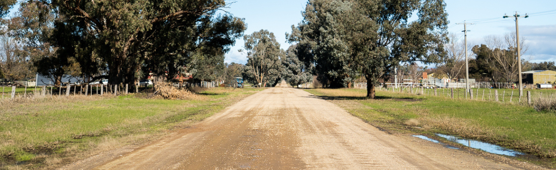
Unsealed roads
The Rural City of Wangaratta manages and maintains a significant network of unsealed roads across both urban and rural areas. These roads are an essential part of our transport infrastructure, particularly in supporting access to rural properties, agricultural operations, and smaller townships.
Council maintains these roads in accordance with the standards outlined in the Road Management Plan. Maintenance activities include grading, pothole repairs, and vegetation management, with intervention levels and response times clearly defined in the Plan.
Residents concerned about the condition of unsealed roads, including requests for grading or pothole repairs, are encouraged to contact Council’s Customer Service team on (03) 5722 0888 or lodge a request online.

Arterial roads (maintained by the Department of Transport and Planning)
Within the Rural City of Wangaratta, arterial roads are managed and funded by the Department of Transport and Planning (formerly VicRoads), as they form part of the state-managed transport network. These roads play a vital role in connecting Wangaratta to surrounding regions and supporting freight, tourism, and local travel. They also include major intersections and overpasses that are critical for regional connectivity and safety. Council is responsible for service roads, footpaths, and roadside infrastructure adjacent to these arterial roads, particularly where they are used by local residents.
Arterial Roads managed by the Department of Transport and Planning (formerly VicRoads) include:
- Greta Road
- Great Alpine Road
- Wangaratta–Beechworth Road
- Wangaratta–Benalla Road
- Ovens Highway
- Mansfield–Whitfield Road
- Hume Freeway (including overpasses like Greta Road and Wangaratta–Eldorado Road)
- Glenrowan–Myrtleford Road
- Snow Road
- Oxley Flats Road
- Warby Range Road
- Beechworth–Wangaratta Road
- Buckland Gap Road
- Federation Way (Declared as Wahgunyah–Wangaratta Road)
- Rutherglen–Springhurst Road
Some roads managed by the Department of Transport and Planning change names several times throughout our rural city:
| Declared Road |
Local Name |
Start Point |
End Point |
| Wangaratta Road |
Glenrowan Road |
Snow Road |
Gravel Pit Road |
| Wangaratta Road |
Tone Road |
Gravel Pit Road |
Greta Road intersection |
| Wangaratta Road |
Ryley Street |
Greta Road intersection |
Ford Street roundabout |
| Wangaratta Road |
Murphy Street |
Ford Street roundabout |
Faithful Street roundabout |
| Wangaratta Road |
Parfitt Road |
Faithful Street roundabout |
North of Parfitt Road ring levee |
| Wangaratta Road |
Bowser Road |
North of Parfitt Road ring levee |
Hume Highway |
| Wangaratta–Yarrawonga Road |
Reid Street |
Murphy Street traffic lights |
Ovens Street roundabout |
| Wangaratta–Yarrawonga Road |
Rowan Street |
Ovens Street roundabout |
Green Street roundabout |
| Wangaratta–Yarrawonga Road |
Green Street |
Green Street roundabout |
Evan Street |
| Wangaratta–Yarrawonga Road |
Evans Street |
Evan Street |
Bend near Clark Street |
| Wangaratta–Yarrawonga Road |
Edward Street |
Bend near Clark Street |
Three Mile Creek bridge |
| Wangaratta–Yarrawonga Road |
Wangaratta–Yarrawonga Road |
Three Mile Creek bridge |
End of road |
| Wangaratta–Whitfield Road |
Warby Street |
Ryley Street |
Meldrum Street |
| Wangaratta–Whitfield Road |
Meldrum Street |
Roger Street |
Bend/change of direction |
| Wangaratta–Whitfield Road |
Millard Street |
Bend/change of direction |
Crisp Street |
| Wangaratta–Whitfield Road |
Murdoch Road |
Crisp Street |
Wenhams Lane |
| Wangaratta–Whitfield Road |
Wangaratta–Whitfield Road |
Wenhams Lane |
Whitfield township |
If you notice a defect or hazard on a sealed arterial road —such as potholes, faded line markings, damaged signage, or vegetation overgrowth—you can report it directly to the Department of Transport and Planning.
Online: Use the VicRoads Road Issue Reporting Form
Urgent Hazards: Call 13 11 70 for immediate concerns that pose a safety risk (e.g. large potholes, fallen trees, or damaged traffic signals).